


About the Nottawasaga Watershed
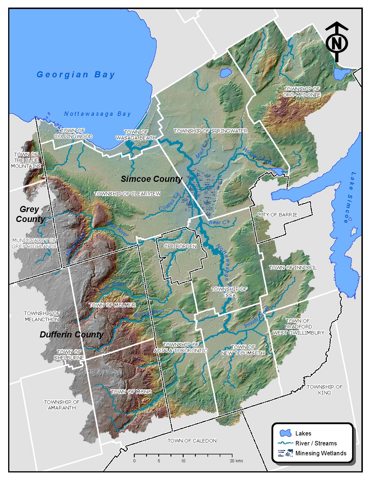
The Nottawasaga jurisdiction is 3,600 km2 and spans from Wasaga Beach in the northeast to Moonstone and Bass Lake, southeast through Barrie and Bond Head to Hwy 9 then eastward to Orangeville then heading north through Collingwood to Nottawasaga Bay. NVCA has a planning role in the northern portions of Springwater and Oro-Medonte Township in the headwaters of river systems that eventually discharge to Severn Sound; however, the Severn Sound Environmental Association completes watershed science activities in this area.
The Nottawasaga Watershed is shaped like a bowl. The rim, or the highest areas of the watershed, are the Niagara Escarpment (a World Biosphere Reserve) to the west, the Oak Ridges Moraine to the south, and the Oro Moraine to the east. At the bottom of the bowl is the Simcoe Lowlands and “chip” of the bowl is Nottawasaga Bay at Wasaga Beach.
The Nottawasaga River is the main river in the 2900 km2 Nottawasaga Watershed. It forms west of the Niagara Escarpment in the Dundalk Till Plains in Amaranth and picks up three major rivers (Boyne River, Pine river, and Innisfil Creek) and countless smaller ones before flowing through the internationally significant Minesing Wetlands. Here, the Mad River and Willow Creek discharge into the Nottawasaga River. As it flows out of the Minesing Wetlands, the Nottawasaga River flows into the Nottawasaga Bay at Wasaga Beach.
The Blue Mountains subwatershed is approximately 222 km2. Here, four rivers form above the Niagara Escarpment, and flow directly into Nottawasaga Bay along the Town of Collingwood shoreline.
Benefits of having a healthy watershed
The Nottawasaga Watershed is situated within 18 municipalities in the counties of Simcoe, Dufferin, and Grey as well as a small area in the Region of Peel. The watershed is mainly made up of rural areas, although there is significant urban development in areas such as Barrie, Alliston, Shelburne, Wasaga Beach and Collingwood. Though most of the land is used for agriculture, natural areas also make up a large part of the landscape.
Our watershed is home to approximately 200,000 people, thousands of farms and businesses. A healthy watershed helps protect and enhance our lives in many different ways.
Human Health
 Our health depends on a healthy watershed. For example, healthy streams provide clean water for drinking and cooking, agricultural irrigation, waste water dilution, and recreational enjoyment.
When we spend time outside, we look for clean rivers, lush forests and areas with abundant wildlife. Activities like exercising, fishing, boating, hiking and bird watching are best enjoyed in these healthy environments. A healthy Nottawasaga Watershed also provides habitat for prized sports fish such as trout, salmon, walleye, pike and bass.
Economic Health

Our local economy is strongly tied to a healthy watershed.
Agriculture is the economic engine of the Nottawasaga Watershed and relies on clean water for irrigation and healthy soils and pollinators to grow crops.
Urban areas also rely on healthy environments as it provides neighbourhoods with access to greenspaces. Our rivers also receive and dilute waste from wastewater treatment plants.
Our strong tourism industry relies on a healthy environment. For example, the Nottawasaga River hosts one of Georgian Bay’s largest salmon runs. Wasaga Beach, the world’s longest fresh water beach is also situated in the watershed.
Ecological Health
 The composition of local plants, animals and their surrounding environment is fundamentally linked to the health of the watershed. Local environments are interconnected and rely on each other. If one or more of these pieces becomes unhealthy, the entire system can suffer, and can affect the economy and our health.
For example, rivers and streams and their surrounding areas help link natural areas across the watershed and are an important part of natural heritage systems. When rivers and streams flood, it helps fertilize the soil and disperse seeds from native plants, greatly benefiting land animals and landscapes. River systems help with nutrient capture and flood attenuation.
That’s why having a healthy watershed and developing it sustainably requires a well thought out plan. NVCA and its partner municipalities work together to manage human activities and natural resources on a watershed basis while considering social, economic and environmental issues for everyone’s benefit.
Plants, Animals and Communities
In the scientific world, that plant and animal communities live within natural heritage features which are often part of natural heritage systems which includes broader natural heritage corridors. This includes the forests, streams, wetlands and renaturalized landscapes that supports plants and animals and their environment. Many of these areas are connected together and form natural heritage corridors. Forests cover just over 30% of the watershed. These include a mix of natural upland forests and swamps as well as planted plantations. Large, significant areas of forest are mapped as Areas of Natural and Scientific Interest (ANSI) by the Province. Thirty eight Life Science ANSIs are present in the watershed. These and other significant woodlands often support significant wildlife habitat and are part of natural corridors within the watershed.
The Province of Ontario has identified the Niagara Escarpment and Oak Ridges Moraine as natural heritage corridors of significance. A lesser known but significant corridor connects the Niagara Escarpment to the Canadian Shield. It passes through the Nottawasaga Watershed and is made up of a system of watercourses, wetlands and forests extending from the Niagara Escarpment northeast through Minesing Wetlands to the Canadian Shield in Severn Township.
Currently, NVCA is mapping the natural heritage features in our watershed so we can see how they are connected, how they work together. The maps will also identify environmentally important systems and areas for habitat restoration.
Visit the NVCA website here
Leave a Reply