


14% protected natural areas is not enough
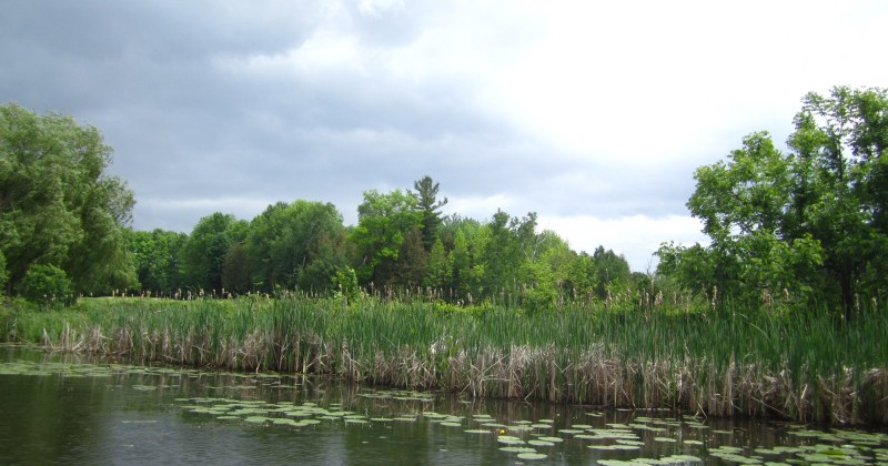
Today we have almost enough forests and wetlands to buffer the watershed from the impacts of climate change and the stress of phosphorus pollution. But we are losing, not gaining, forests and wetlands.
Stronger, strategic protections needed in Simcoe County, report shows
News release from Rescue Lake Simcoe Coalition
The Rescue Lake Simcoe Coalition released a report and maps over the long weekend which show that only 14% of Simcoe County’s natural lands are well protected. And even the strictest land protection policies allow for aggregate activity, which has the potential to remove some of the best protected lands. Ultimately the report concludes that Simcoe County does not meet Federal habitat protection guidelines, and that much more substantial protections for natural features and linkages are needed.
Anyone can see that forests and wetlands are being lost in Simcoe County. The report asks, are our current policies protecting enough forests and wetlands to buffer the area’s water and ecosystems from the impacts of development, climate change, and fragmentation of the natural heritage system? The research indicates, the answer is no.
Simcoe County’s Natural Heritage System looks big, but 58% of the County’s land is covered by policies that allow for a ‘death by a thousand cuts’. Development applications often result in the removal of Simcoe County’s Environmental Protection designation. The result is the loss of linkages between well protected natural features. This is not helpful for animals on the move, or general ecosystem health.
The silver lining is that same 58% category. Simcoe County and its municipalities are in a position to increase the level of protection for a greater portion of the County by implementing Conservation Authorities’ Natural Heritage Systems and strategies, setting ecologically based, local targets, and by getting all wetlands evaluated and protected.
“We are not out to denigrate any agency or actor involved in making land use applications or decisions. But we need to point out that today’s policy regime is inadequate at protecting an appropriate amount of greenlands for the long term. If we don’t set a higher bar for protecting natural features we will continue to experience a loss of water quality, species, and ecosystem health,” says Claire Malcolmson, long time Lake Simcoe advocate and Executive Director of the Rescue Lake Simcoe Coalition. “That is not a legacy we will be proud to leave for our kids. Last I checked, kids did not love algae-strewn beaches.”
How well protected are greenlands[i] in Simcoe County?
Simcoe County total land area, excluding water:
14% Best Protected, level 1
58% Somewhat Protected, level 2
28% Not Protected, level 3
Full report
The Rescue Lake Simcoe Coalition’s greenlands mapping project seeks to identify how well protected Simcoe County forests, wetlands and shorelines are by analyzing the strength of the policies applied to the features that make up area greenlands, and mapping the results. University of Guelph cartographers created four maps for this research, showing the land use mix in Simcoe County, the breakdown of the levels of protection, the locations of aggregate resources that could eat into the best protected greenlands, and the features identified in the RLSC report’s “Best Protected” category.
What should we have?
Forest cover
50% forest cover or more at the watershed scale equates to a low-risk approach that is likely to support most of the potential species, and healthy aquatic systems.[ii]
– Simcoe County has 22%, but is losing forest cover.
Wetlands
The greater of (a) 10% of each major watershed and 6% of each subwatershed, or (b) 40% of the historic watershed wetland coverage, should be protected and restored, and no net loss of wetlands. [iii]
– Simcoe County has 14% wetland cover based on our analysis, and approximately half of its historic wetland cover.[iv] Simcoe County is losing wetlands. [v]
Margaret Prophet, Executive Director of the Simcoe County Greenbelt Coalition was involved in the development of the report. She says, “This research verifies what we at the Simcoe County Greenbelt Coalition have been saying for over 3 years – our green spaces and waters are not adequately protected or respected. Each day that goes by that we dig and pave, we threaten our water, our climate, our biodiversity and our very survival. We hope that political leaders recognize the opportunity and need to permanently protect and steward our environment. We can no longer afford dithering and delays.”
Simcoe County’s land use mix does not meet ideal greenlands protection targets, but it is possible to get it right in Simcoe County, and permanently protect an effective Natural Heritage System to buffer the local waters and ecosystem from the impacts of climate change and development, the report concludes.
Solutions
– Municipalities and the County should implement the Growth Plan’s Natural Heritage System for the Greater Golden Horseshoe and related policies as soon as possible to better protect linkages between the best protected natural features;
– Ensure First Nations’ perspectives and Traditional Ecological Knowledge are incorporated into provincial policies that protect natural heritage;
– To achieve “no net loss”, all wetlands should be formally evaluated, identified and protected in the County’s Natural Heritage System;
– Permanently protect “high quality natural cover” in the review of the Lake Simcoe Protection Plan;
– Expand the Greenbelt into Simcoe County;
– Build denser communities to reduce the need to build on greenlands.
The Rescue Lake Simcoe Coalition is a lake-wide member-based organization that provides leadership and inspires people to take action to protect Lake Simcoe.
More information
The Greenlands Report : How well protected are Greeenlands in Simcoe County?
Materials and maps available for download
Notes
[i] In the context of this report greenlands are primarily forests and wetlands, and the buffers around forests, wetlands, lakes and rivers, that make up Simcoe County’s Natural Heritage System, or NHS. Our analysis excludes water bodies.[ii] Environment Canada. 2013. “How Much Habitat Is Enough?” Third Edition. Toronto, Ontario: Environment Canada. https://www.ec.gc.ca/nature/default.asp?lang=En&n=E33B007C-1#_01.
[iii] Ibid
[iv] Ducks Unlimited. 2010. “Southern Ontario wetland conversion analysis.” p. 8.
[v] Nottawasaga Valley Conservation Authority. 2013. “Watershed health checks, 2002 – 2008.” https://www.nvca.on.ca/watershed-science/watershed-report-cards
Leave a Reply